
Wind gusts reached 109 mph at the National Center for Atmospheric Research’s Mesa Laboratory in Boulder on Wednesday, while a wind sensor at Rocky Flats National Wildlife Refuge recorded 102 mph gusts and a west Boulder County sensor near Fourmile Canyon recorded 95 mph winds, according to the National Weather Service’s Boulder office.
This type of windstorm is not unusual for Colorado in the fall and winter, but it may have caught people off guard because the state hasn’t seen anything similar in the past four years, weather service meteorologist Robert Koopmeiners said.
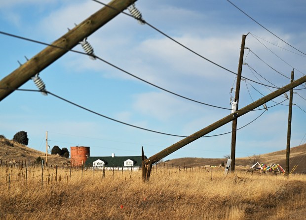
In December 2021, similar extreme winds and tinder-dry conditions allowed the Marshall fire to race across Boulder County, killing two people and destroying more than 1,000 homes. A Boulder County district attorney’s investigation found downed Xcel Energy lines sparked the fire, although the company continues to deny its equipment was responsible.
Winter windstorms are “not a surprise,” Koopmeiners said. “We have these areas that are very favored for those downsloping winds, and those are the areas that got it.”
Denver-area weather should be comparatively calm Thursday, with a high near 47 degrees and winds around 10 mph, according to forecasters.
But Friday is a different story, and Front Range residents should brace for a repeat of Wednesday’s weather, Koopmeiners said. A new storm system likely will bring winds that are just as strong — if not stronger — to the Front Range starting midmorning Friday and lasting into the late evening.
Friday also could bring record-high temperatures in Denver, with DIA forecast to reach 68 degrees. The previous daily record, 67 degrees, was last set in 2023.
Although the worst impacts of Wednesday’s storm stuck to the foothills, winds picked up throughout the Denver area and Interstate 25 corridor. Wind gusts reached 83 mph at Rocky Mountain Metropolitan Airport in Broomfield, 47 mph at Centennial Airport and 32 mph at DIA, according to the weather service.
The storm also pushed winds to 52 mph at the Northern Colorado Regional Airport in Loveland and 35 mph at the Colorado Springs Airport.
Xcel Energy leaders preemptively cut power to approximately 50,000 customers in Boulder, Clear Creek, Jefferson, Larimer and Weld counties on Wednesday morning as the storm picked up, a move meant to prevent downed powerlines from starting wildfires.
As of 6:30 p.m., Xcel crews were responding to 176 unplanned outages affecting 113,560 customers in Adams, Denver, Jefferson, Boulder, Larimer, Weld, Arapahoe, Broomfield, Douglas, Eagle and Clear Creek counties, according to the utility’s outage map.
CORE Electric reported 16,313 customers without power in Clear Creek, Douglas, Jefferson, Park and Teller counties on Wednesday night.
Several school districts and colleges also preemptively canceled classes because of expected power outages, including the University of Colorado, Red Rocks Community College and schools in Clear Creek, Weld RE-4 and Poudre school districts.
Jeffco Public Schools canceled all Wednesday classes late Tuesday, which district officials said “reflects the consideration that went into it as well as the evolving nature of the situation.”
Impacts of the winds rippled throughout Colorado’s transportation systems on Wednesday, with delays, closures and cancellations hitting highways, public transport and the Denver airport.
Colorado Department of Transportation officials closed several highways through the foothills and northern Colorado starting at noon and stopped high-profile vehicles, like tractor-trailers and RVs, from traveling on the Peak to Peak highway.
Road safety closures were still active as of 7 p.m. Wednesday for U.S. 287 between Ted’s Place in Larimer County and the Wyoming state line; Colorado 93 between Colorado 128 and Colorado 72; Colorado 128 between McCaslin Boulevard and Colorado 93; and U.S. 36 north of Boulder to Lyons.
In the west metro area, planned power cuts caused the Regional Transportation District to close three light rail stations serving the W-Line between the Jefferson County Government Center Station in Golden to Union Station in Denver. RTD officials replaced train service with buses.
Airlines reported 393 flight delays and 12 flight cancellations Wednesday night, according to the flight tracking website FlightAware.
Not even the holiday spirit could escape the wind Wednesday, with Denver tourism officials canceling the Denver Christkindlmarket and Mile High Drone Show and removing access to the Mile High Tree because of the storm.
More public safety power cuts are possible during Friday’s storm, according to Xcel Energy.
Get more Colorado news by signing up for our daily Your Morning Dozen email newsletter.