Snow in Alabama’s weather forecast: Will it really happen?
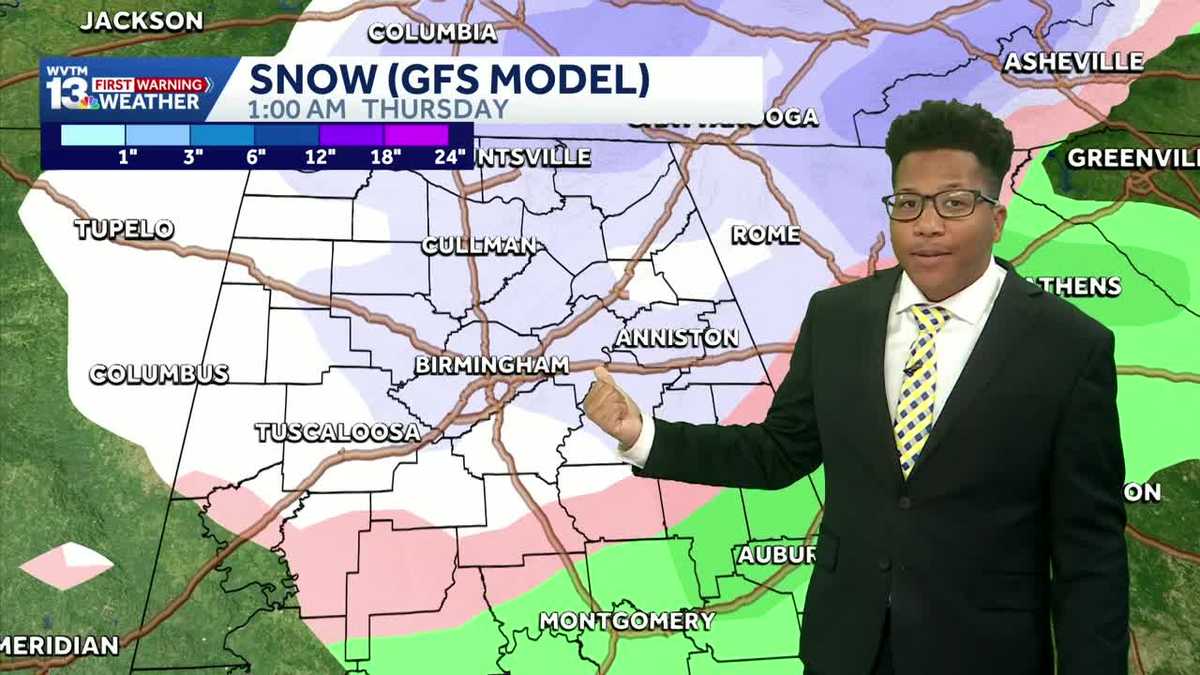
IT’S BEEN A COLD DAY ACROSS CENTRAL ALABAMA. BIRMINGHAM CLIMBED UP TO 50 DEGREES TODAY, WHICH IS ACTUALLY BELOW AVERAGE FOR THIS TIME OF YEAR, SOMETHING WE HAVEN’T SEEN FOR QUITE SOME TIME. BIRMINGHAM RIGHT NOW AT 44. WE’RE DROPPING QUICKLY. IT FEELS LIKE 39 DEGREES OUT THERE BECAUSE THE WIND COMING IN OUT OF THE NORTH AND IT’S GUSTING PRETTY WELL UP TO TEN MILES PER HOUR RIGHT NOW. AND TEMPERATURES ACROSS THE BOARD SHOW A SIMILAR STORY. 39 UP THERE IN HALEYVILLE, 39 IN HUNTSVILLE, 46 RIGHT NOW IN SYLACAUGA, AND EVEN 48 DEGREES OUT IN TUSCALOOSA TO THE REST OF THIS EVENING SHOULD BE DRY, BUT CHILLY WILL DROP BELOW FREEZING AFTER 10:00 TONIGHT. AND THEN, YEAH, WE WAKE UP TOMORROW MORNING WITH TEMPERATURES IN THE MID TO UPPER 20S ACROSS THE BOARD FROM 26 UP IN CULLMAN COUNTY TO 26 IN CHILDERSBURG, 27 IN ALABASTER 27 OUT THERE IN SAMANTHA TWO. WE WARM UP QUICKLY THOUGH. UPPER 40S, LOWER 50S, KIND OF LIKE WE DID TODAY. WE’LL SEE LOTS OF SUNSHINE DURING THE AFTERNOON AND EVENING HOURS, BUT THEN TEMPERATURES DROP DOWN BELOW FREEZING YET AGAIN EARLY TUESDAY MORNING FROM 25 IN GADSDEN TO 28 IN SYLACAUGA, 27 IN JASPER 28 OUT THERE IN T-TOWN TOO. WE’RE FINALLY STARTING TO FEEL A WHOLE LOT LIKE WINTER. BUT COMES WINTER SOMETIMES COME THE POTENTIAL FOR SOME SNOW AND WE HAVE THAT POTENTIAL, BUT A LOT TO BREAK DOWN HERE. WE HAVE A WEAK FRONT COMING IN WEDNESDAY INTO THURSDAY, AND THAT’S WHAT I’M SHOWING YOU NOW. THIS IS GOING TO BE A COLD RAIN 4:00 WEDNESDAY AFTERNOON. AND AFTER THAT RAIN WITH THAT POTENTIAL FOR SOME SNOW OR EVEN LIGHT FLURRIES. AND NORTHEAST ALABAMA. THIS IS JUST ONE MODEL, THE EUROPEAN MODEL IN THIS CASE, AND IT’S NOT SHOWING MUCH OF RAINFALL TOTALS AS WE WORK OUR WAY INTO THE REST OF THE EVENING AND EVEN INTO THE MORNING HOURS, SOME FLURRIES UP IN DEKALB COUNTY, MAYBE CHEROKEE COUNTY, LOW IMPACT. AND THIS IS THE MODEL WHERE THERE’S HIGHER CONFIDENCE. THIS IS THE MOST LIKELY SCENARIO. NOW I’M GONNA SHOW YOU THE MOST LIKELY SCENARIO, BUT I’M ALSO GOING TO SHOW YOU THE WORST CASE SCENARIO. THIS IS THE GFS MODEL. ONCE AGAIN RAIN DURING WEDNESDAY EVENING. BUT LOOK AT THAT. A GOOD BIT OF SNOW COMING IN BACK BEHIND THIS FRONT EARLY THURSDAY MORNING. THIS ONE A HIGHER IMPACT BUT ONCE AGAIN LESS LIKELY IT’LL HAPPEN. AND AS YOU CAN SEE THIS WHITE COLOR HERE, THAT’S ABOUT A HALF AN INCH OF SNOW. SOME SPOTS SEEING A LOT OF FLURRIES. WE’LL HAVE TO CONTINUE TO WATCH THIS TO SEE HOW THIS CHANGES OVER THE NEXT SEVERAL DAYS. SO DON’T PICK A MODEL. BUT IF THE WORST CASE SCENARIO HAPPENS, OF COURSE WE’LL LET YOU KNOW. RIGHT NOW WE’RE LEANING TOWARDS JUST A FEW FLURRIES IN NORTHEAST ALABAMA, AND THEN IT’S CHILLY PRETTY MUCH EVERY MORNING THIS WEEK. MOST MORNINGS THIS WEEK ARE BELOW FREEZING, EXCEPT WEDNESDAY. A LOT MORE SUNSHINE, A COLD RAIN, WEDNESDAY, MAYBE SOME FLURRIES THURSDAY, AND WE’LL EVEN HAVE TO KEEP AN EYE OUT FOR SO
Snow in Alabama’s weather forecast: Will it really happen?
Updated: 6:12 PM CST Jan 11, 2026
Snow flurries could return to Alabama’s weather forecast overnight Wednesday into Thursday as temperatures drop below freezing and a cold front sweeps across the state.
With Alabama feeling a lot more like winter this week, the question on everyone’s mind is the potential for snow.
A weak front is set to move through the region Wednesday into Thursday. While some social media posts are showing significant accumulation, the data tells a more nuanced story. Currently, we are tracking two primary scenarios:
The likely scenario (European model)
This is the outcome we have the highest confidence in. It suggests a cold rain moving in Wednesday afternoon, potentially ending as light flurries in northeast Alabama — specifically DeKalb, Jackson, Marshall, Madison, Limestone, Morgan, and Cherokee counties — around 12 a.m. Thursday. This would be a low-impact event with no major travel concerns.
The “worst-case” scenario (GFS model)
This model is more aggressive, showing rain transitioning to snow after midnight Wednesday. This scenario could result in roughly a half-inch of accumulation in some areas. While this would have a higher impact on travel, it is currently the least likely outcome.
The bottom line
At this point, we are leaning toward the “cold rain and flurries” scenario for northeast Alabama. In our state, it only takes a few degrees to change rain to ice, so we will watch the trends closely.
