A brief rain-to-snow mix possible across Upstate, South Carolina, on Sunday morning. Timing looks to be 7 a.m. – 11 a.m.Accumulation amounts are less than an inch.7 a.m.: Flurries spotted on our live Paris Mountain camera. Check it out here or below. Here’s the video ICYMI: Latest update from Meteorologist Grace Lowe: (Sunday morning)Light snow is possible this morning as snowfall trends have shifted slightly westward, but the amount remains below any advisory. Watch Grace Lowe live throughout the morning here. Areas through the Upstate should observe some snowfall this morning as rain slowly could transition into snowfall through this morning. Timing looks to be 7 a.m. – 11a.m. Accumulation amounts are less than an inch with a rain/snow mix still waiting to see how cold we are going to get through the morning. A dusting is more likely than any higher amounts of snowfall. This is a low impact event, with minimal travel concerns. Highs are in the low 40s in the upstate, low 30s in the mountains. Precipitation lasts through 3 p.m., cold continues through the holiday. Latest update from Meteorologist Bradford Ambrose: A Live Super Doppler 4 Impact Day is in effect for Sunday due to the potential for measurable snow.(Don’t have time to read this, check out our maps and graphics for a quick look at what to expect. Tap HERE.)Timing: Forecast models suggest that cold air will catch up to the precipitation, particularly in areas along and southeast of I-85. The best chance of seeing snow is expected between 7 a.m. and noon. Amounts: Accumulation is anticipated to be less than one inch. Any snow that falls will primarily accumulate on elevated surfaces such as decks and lawns.Currently, winter weather alerts are not in effect for the viewing area.With any leftover moisture on the roads, black ice could form early Monday morning as temperatures drop into the teens and 20s.Latest update from Chief Meteorologist Chris Justus: (Sunday afternoon)This is an important trend to watch heading into the evening runs. The midday NAM came in 4–7° warmer for Sunday morning compared to its previous run. That matters, because it means more of the initial precipitation falls as rain before any transition to snow.Because of that, expectations continue to lean toward light snow showers to a dusting for many areas — which has been the common theme today.If there’s going to be a surprise quick hit, the data still points south of Atlanta in Georgia, and north again into the Triad / Raleigh area, where timing between cold air and moisture lines up a little better.I’ll keep watching closely as the evening data comes in and update you if that trend changes.Timing: Sometime between 5 a.m. and 11 a.m. Sunday. (Timing will come more into focus as we move closer)✅ Asheville → Greenville → Spartanburg → Anderson → Athens → AtlantaLight snow possible, minor impact. Mostly grass, trees, and elevated surfaces.✅ Charlotte → Columbia → Rock Hill → Statesville → Mooresville → FoothillsSnow falling at times with minor impacts.👉 This corridor has the best chance for a surprise higher amount, generally 1–2 inches at most, which could mean a few slick spots.Overall, this is not the big one. We don’t have strong cold air locked in or a classic setup with high pressure to the north and a deep coastal low. That said… 👀 the models do hint at a more favorable pattern later this month.I’ll keep you posted today as trends settle in.(We will continue to update this story as the models come in) Saturday morning update from Chris Justus: (Sunday morning) We’re about 24 hours out from what looks like a minor winter weather event — but one that could still bring the first snow many areas have seen in years.I know the frustration with this system. It’s been volatile because we’re dealing with a small, fast-moving piece of energy high in the atmosphere. Trust me, it has been frustrating to forecast! And in situations like this, you can never be definitive when forecasting.That’s why the Hurricane Hunters ✈️ — yes, the same aircraft used for tropical systems — sampled the atmosphere yesterday and again today to improve model data. Once that information was ingested last night, several models shifted the system farther northwest, bringing parts of southern Alabama, Georgia, and the western Carolinas back into play.Here’s what matters most right now:• Limited moisture available 🌫️• Cold air can get trapped west of the mountains 🏔️• Totals depend on how quickly rain flips to snow 🌡️➡️❄️Details: Light rain may begin shortly after midnight with temperatures near 40°, then gradually cool toward freezing. If we spend enough time in snow, we could see wet snow coating grass and elevated surfaces — what I’d call a novelty or “Instagram” snow 📸❄️ for many.Right now, average liquid amounts look to be around 0.30–0.50”, which means outcomes range from flurries to localized light accumulation. I’m especially watching the I-77 corridor, including Charlotte, where a narrow deformation band could enhance snowfall if it sets up just right 🎯. Pinpointing that feature is next to impossible, but I do know it’s going to form somewhere as the energy shifts in the upper parts of the atmosphere.🔹 Bottom line:Snow likely falls in many spotsThis is not a major stormRoads should generally be OK, though slick spots are possible where totals approach an inch or more 🚗⚠️I’ll share updated snow ranges later today once we see the full morning model suite. My commitment remains the same: transparent updates, realistic expectations, and my honest expertise — especially with tricky systems like this.
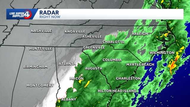
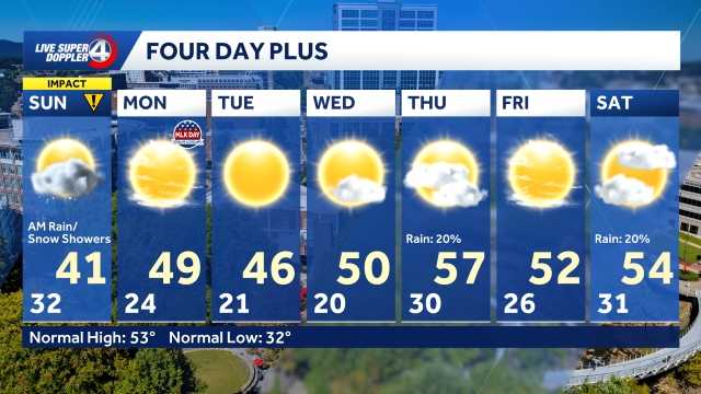
A brief rain-to-snow mix possible across Upstate, South Carolina, on Sunday morning.
Timing looks to be 7 a.m. – 11 a.m.
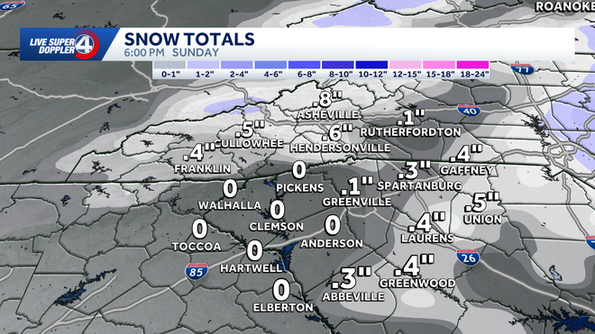
Accumulation amounts are less than an inch.
7 a.m.: Flurries spotted on our live Paris Mountain camera. Check it out here or below.
Here’s the video ICYMI:
Latest update from Meteorologist Grace Lowe: (Sunday morning)
Light snow is possible this morning as snowfall trends have shifted slightly westward, but the amount remains below any advisory.
Watch Grace Lowe live throughout the morning here.
Areas through the Upstate should observe some snowfall this morning as rain slowly could transition into snowfall through this morning.
Timing looks to be 7 a.m. – 11a.m.
Accumulation amounts are less than an inch with a rain/snow mix still waiting to see how cold we are going to get through the morning. A dusting is more likely than any higher amounts of snowfall.
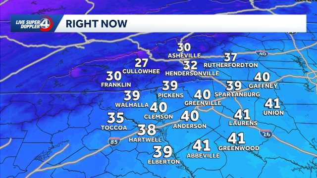
This is a low impact event, with minimal travel concerns. Highs are in the low 40s in the upstate, low 30s in the mountains.
Precipitation lasts through 3 p.m., cold continues through the holiday.
Latest update from Meteorologist Bradford Ambrose:
A Live Super Doppler 4 Impact Day is in effect for Sunday due to the potential for measurable snow.
(Don’t have time to read this, check out our maps and graphics for a quick look at what to expect. Tap HERE.)
Timing: Forecast models suggest that cold air will catch up to the precipitation, particularly in areas along and southeast of I-85. The best chance of seeing snow is expected between 7 a.m. and noon.
Amounts: Accumulation is anticipated to be less than one inch. Any snow that falls will primarily accumulate on elevated surfaces such as decks and lawns.
Currently, winter weather alerts are not in effect for the viewing area.
With any leftover moisture on the roads, black ice could form early Monday morning as temperatures drop into the teens and 20s.
Latest update from Chief Meteorologist Chris Justus: (Sunday afternoon)
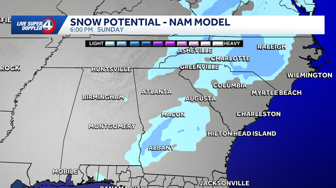
This is an important trend to watch heading into the evening runs. The midday NAM came in 4–7° warmer for Sunday morning compared to its previous run. That matters, because it means more of the initial precipitation falls as rain before any transition to snow.
Because of that, expectations continue to lean toward light snow showers to a dusting for many areas — which has been the common theme today.If there’s going to be a surprise quick hit, the data still points south of Atlanta in Georgia, and north again into the Triad / Raleigh area, where timing between cold air and moisture lines up a little better.I’ll keep watching closely as the evening data comes in and update you if that trend changes.
Timing: Sometime between 5 a.m. and 11 a.m. Sunday. (Timing will come more into focus as we move closer)
✅ Asheville → Greenville → Spartanburg → Anderson → Athens → Atlanta
Light snow possible, minor impact. Mostly grass, trees, and elevated surfaces.
✅ Charlotte → Columbia → Rock Hill → Statesville → Mooresville → Foothills
Snow falling at times with minor impacts.
👉 This corridor has the best chance for a surprise higher amount, generally 1–2 inches at most, which could mean a few slick spots.
Overall, this is not the big one. We don’t have strong cold air locked in or a classic setup with high pressure to the north and a deep coastal low. That said… 👀 the models do hint at a more favorable pattern later this month.
I’ll keep you posted today as trends settle in.
(We will continue to update this story as the models come in)
Saturday morning update from Chris Justus: (Sunday morning)
We’re about 24 hours out from what looks like a minor winter weather event — but one that could still bring the first snow many areas have seen in years.
I know the frustration with this system. It’s been volatile because we’re dealing with a small, fast-moving piece of energy high in the atmosphere. Trust me, it has been frustrating to forecast! And in situations like this, you can never be definitive when forecasting.
That’s why the Hurricane Hunters ✈️ — yes, the same aircraft used for tropical systems — sampled the atmosphere yesterday and again today to improve model data. Once that information was ingested last night, several models shifted the system farther northwest, bringing parts of southern Alabama, Georgia, and the western Carolinas back into play.
Here’s what matters most right now:
• Limited moisture available 🌫️
• Cold air can get trapped west of the mountains 🏔️
• Totals depend on how quickly rain flips to snow 🌡️➡️❄️
Details: Light rain may begin shortly after midnight with temperatures near 40°, then gradually cool toward freezing. If we spend enough time in snow, we could see wet snow coating grass and elevated surfaces — what I’d call a novelty or “Instagram” snow 📸❄️ for many.
Right now, average liquid amounts look to be around 0.30–0.50”, which means outcomes range from flurries to localized light accumulation. I’m especially watching the I-77 corridor, including Charlotte, where a narrow deformation band could enhance snowfall if it sets up just right 🎯. Pinpointing that feature is next to impossible, but I do know it’s going to form somewhere as the energy shifts in the upper parts of the atmosphere.
🔹 Bottom line:
Snow likely falls in many spots
This is not a major storm
Roads should generally be OK, though slick spots are possible where totals approach an inch or more 🚗⚠️
I’ll share updated snow ranges later today once we see the full morning model suite. My commitment remains the same: transparent updates, realistic expectations, and my honest expertise — especially with tricky systems like this.
</div>
