The video player above is a live stream of WBTV and affiliated programming, and may not be directly related to the article below.
CHARLOTTE, N.C. (WBTV) – Hundreds of flights were canceled and a handful were delayed Sunday morning at Charlotte Douglas International Airport as a winter storm brought sleet and freezing rain to the Carolinas.
As of 5:45 p.m. on Sunday, Jan. 25, there were over 1,100 flight cancelations and over 120 flight delays at Charlotte Douglas International Airport, according to flight-tracking website FlightAware. The majority of affected flights appeared to be with American Airlines.
Click here to see the latest numbers of cancelations and delays for the Charlotte airport.
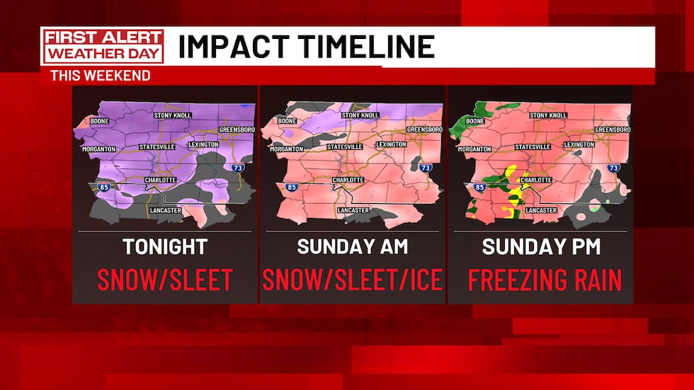
The flight disruptions on Sunday came as a winter storm moved from west to east across the U.S., arriving in the Carolinas late Saturday. Snow and sleet were possible early Sunday for some, with freezing rain in the forecast for most areas throughout the day.
The bulk of the freezing rain on Sunday was expected in the afternoon, according to our First Alert meteorologists.
Click here for the most up-to-date winter storm forecast.
An accumulation of freezing rain, which is essentially ice, could significantly impact travel on Sunday and in the coming days. Roadways could become dangerous, if not impassible, at some points this weekend and into early next week due to the ice.
Power outages were also possible across the region due to the storm. Ice could accumulate on power lines and tree branches, which could damage power lines and cause widespread outages.
—> More: Power outages possible across Carolinas with winter storm: How to prepare
Scroll down for a full storm forecast breakdown from First Alert meteorologist Eric Garlick. You can also visually track the storm in the interactive radar immediately below.
Storm forecast
Meteorologist Eric Garlick writes:
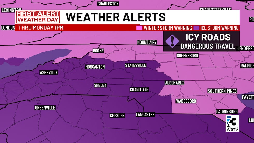
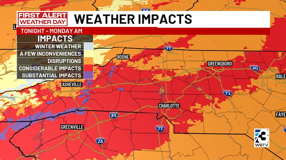
An ice storm warning was in place for most locations in our region on Sunday. Those that are not included in the ice storm warning are included in a winter storm warning.
Ice is the main threat with this incoming winter storm, and impacts could last for several days.
The worst of the winter storm is expected in North and South Carolina on Sunday, particularly in the afternoon.
Here’s a look at what to expect and when.
The big picture: A setup for freezing rain
A very strong arctic high-pressure system is pushing cold air south and locking it in place at the surface (this is called cold air damming). At the same time, deep moisture moves in overhead. That combination is a classic freezing rain setup, and temperatures will be well below freezing while this is happening.
Because temperatures are colder than many past ice events, ice may stick and accumulate quickly, especially on untreated roads, trees, and power lines.
—> Related: Freezing rain, sleet possible in Carolinas amid winter storm: Here’s how they’re different
Sunday storm timeline – the worst day
Temperatures: Low 23°F / High 30°F
- 100% chance of freezing rain.
- Transition to widespread freezing rain by morning.
- Ice continues to accumulate all day long.
- Tree damage and power outages become widespread.
- Road conditions: Impassable; ice coating all surfaces.
What’s Happening: Freezing rain is now the dominant precipitation type throughout Sunday. Strong warm air advection aloft combined with persistent cold air at the surface creates continuous ice accumulation. This is when power outages begin to occur as ice weight accumulates on trees and power lines. The cold air damming is at its peak intensity.
Sunday evening forecast
- Freezing rain continues.
- Additional ice accumulation possible (0.1-0.2 inches).
- Conditions remain hazardous.
- A final band of heavier precipitation possible as the primary low transitions from the Tennessee Valley to a coastal low.
- Road conditions: Still impassable; additional ice possible.
What’s Happening: The main forecast uncertainty is whether temperatures will rise above freezing by the time this final band arrives. If temps stay below freezing, additional ice accumulation occurs. If temps rise above freezing, some rain is possible. Cold air damming begins to erode as the upper flow pattern becomes phased.
Expected accumulation
The amount of snow and ice accumulation will be enough to cause serious impacts.
Snow totals
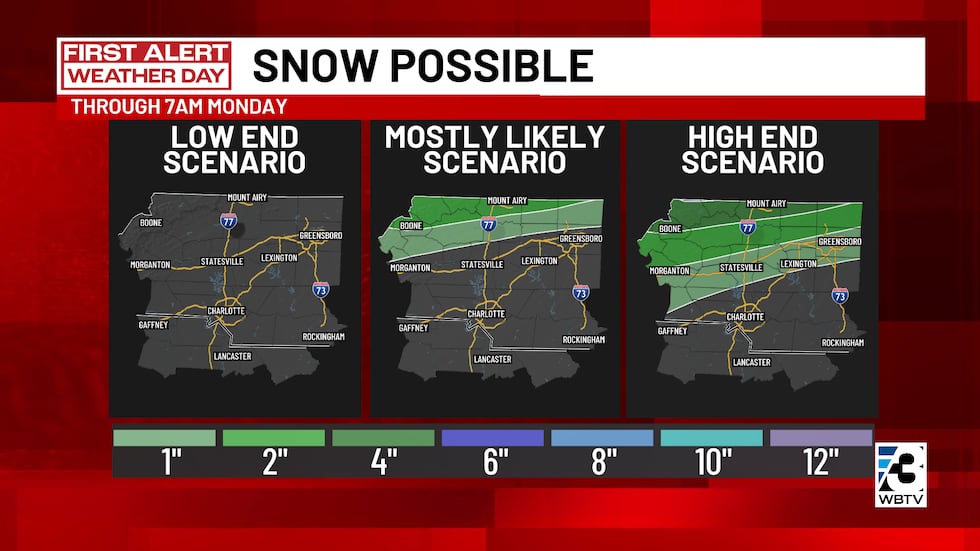
- North of I-40: 2-4 inches (mountains only).
- Timing: Early Saturday afternoon, brief period before transition to sleet/freezing rain.
Sleet totals
- South of I-40: 1-3 inches.
- Timing: Saturday evening through Sunday morning.
- Note: Sleet will be buried under ice that accumulates.
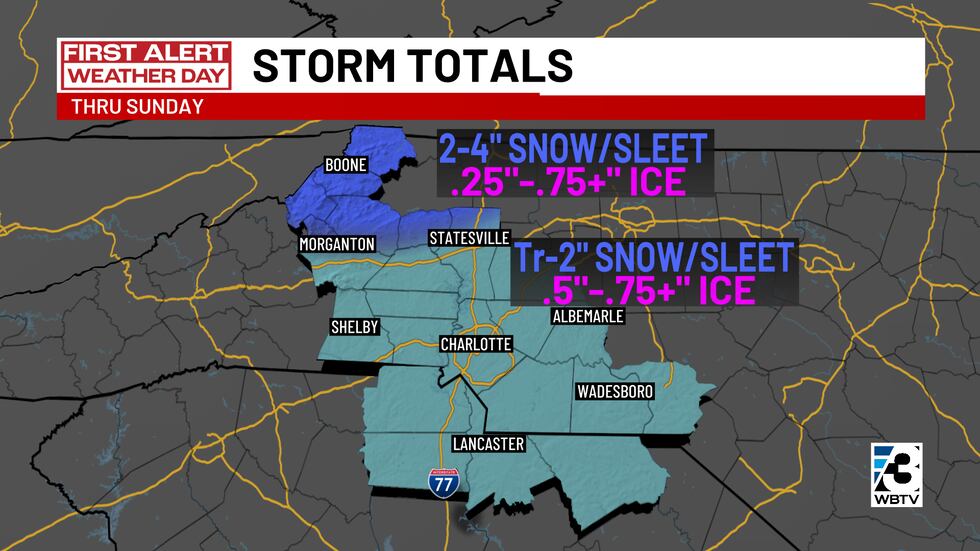
Ice (freezing rain) totals
- Most areas (Charlotte metro): 0.50-0.75 inches or more.
- Mountains: 0.20-0.50 inches or more.
- Timing: Primarily Sunday morning through Sunday evening.
- Note: Even 0.25 inches of ice can cause problems — these amounts are well beyond that threshold.
Expected impacts & hazards
Icy roads, potentially impassable at times
- Travel will be extremely dangerous Saturday evening through Sunday evening.
- Black ice concerns continue through the week.
Widespread power outages, long-lasting
- Power outages could last for days, not just hours.
- Some areas could be without power through Monday, Tuesday, or even longer if damage is severe.
- This is a public health concern, especially combined with extreme cold.
Dangerous travel conditions lasting beyond the storm
- Icy roads will remain hazardous through Wednesday/Thursday.
- Refreezing each night will create black ice.
- Limited melting due to slow temperature recovery.
Bottom line
This is a significant and dangerous ice storm, not just a wintry mix.
Sunday is the highest-impact day, but problems may linger into next week due to cold temperatures.
Click here to see more of the breakdown from Eric Garlick.
Upload your winter weather pictures
Share your photos or videos of the winter weather to the QCit album below, and we may feature them on TV or online.
Be sure to note what city, town, or village the photo was taken in — we may come check it out for ourselves.
Download the free WBTV Weather app on your mobile device to receive weather alerts and to get the latest forecast on the go. You can also catch the latest forecast on WBTV’s streaming app — find it in the app store on your smart TV or streaming device.
Copyright 2026 WBTV. All rights reserved.