
Enjoy the melting out there today because another mix of rain, snow and ice is heading our way.
While there will be a late week pause in the spring feel, much more of a spring is on the next week, with highs in the 60s. The normal for this time of year is 42 degrees, so it’s nice to break away from the cold and below normal trend for much of February.
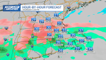
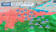
Temperatures are dropping quickly again tonight, setting the stage for our next system, which comes in by late Thursday afternoon into early Friday, bringing another messy winter mix.
Winter Weather Advisories have already been issued for parts of New England from late Thursday through midday Friday.
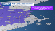
Most of southern New England starts with rain and freezing rain Thursday afternoon. Colder air at the surface becomes more abundant in the evening, leading to more pockets of freezing rain and sleet, mainly along and north of the Mass. Pike. That’s where ice and snow accumulation will create slippery travel through morning commute time on Friday.
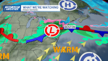
After this system, attention turns to a warming trend. Temperatures begin climbing this weekend and could surge well above normal early next week, with highs pushing into the 50s and even the 60s.