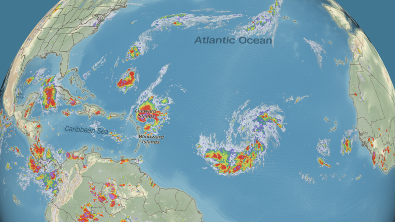
Tropical Storm Gabrielle has formed in the central Atlantic Ocean, putting an end to an unusual nearly three-week stretch with no storms during the peak of hurricane season.
Gabrielle formed Wednesday morning just over 1,000 miles from the Caribbean’s northern Leeward Islands, with sustained winds of 45 mph.
The National Hurricane Center forecast calls for Gabrielle to become a hurricane by Saturday as it churns to the north–northwest. Although the water is plenty warm for strengthening, the storm faces some hurdles in the atmosphere over the next couple of days, so it’s still uncertain how strong it could become.
The United States is not expected to see direct impacts from this system, but it might churn up surf on the East Coast next week.
Gabrielle is the first tropical storm in the Atlantic since Fernand fizzled on August 28.
For only the second time since 1950, the Atlantic went storm-free from August 29 through September 16, according to Dr. Phil Klotzbach, a hurricane expert and research scientist at Colorado State University. The last time that happened was in a quiet period after Hurricane Andrew’s devastating strike on the US in 1992.
High pressure to the north of this system will act as a steering wheel the next few days, with its clockwise motion sending the storm on a west-northwest path that will take it north of the islands of the eastern Caribbean by this weekend. High surf and dangerous rip currents will be the main impacts in those islands, including Puerto Rico and the Virgin Islands.
That high pressure will then weaken enough to turn the system more north into the central Atlantic. Where that turn occurs will determine how close it tracks to Bermuda next week.
Another area of showers and storms is emerging from Africa right behind Tropical Depression Seven and could develop slowly into another tropical system as it tracks west across the eastern and central Atlantic in the coming days, the National Hurricane Center says. This system is no imminent threat to land for at least the next week, regardless of whether it becomes a tropical depression or storm.
The seventh tropical storm of the season typically forms by September 3, so this storm is about two weeks late.
Most tropical activity in the Atlantic – depressions, storms and hurricanes – occurs from mid-August to mid-October. But most of September is typically very busy, as it’s when multiple atmospheric and oceanic conditions combine to make it easy for tropical systems to spring to life.
This September has had plenty of warm water to serve as jet fuel for tropical trouble. Sea surface temperatures across the basin are currently warmer than normal and have been that way for most of the summer.
But of the season’s six tropical storms through August, only one has become a hurricane: Erin. Erin was a frightening peek into a new world order of how strong Atlantic storms are becoming as the planet warms.
The Atlantic has struggled to produce storms this year because of factors above the ocean.
The tropical Atlantic has been enveloped in dry, stable air. This factor can help limit any wannabe tropical systems from producing stormy weather.
Storm-killing winds in different levels of the atmosphere known as wind shear have also been stronger than usual for this time of year in western and central parts of the Atlantic.
Those two atmospheric factors have been a hindrance for the formation of tropical systems from areas of stormy weather that move off the coast of Africa and into the open Atlantic this time of year.
The breeding ground for storms shrinks westward away from Africa heading into October. The Gulf, Caribbean and western Atlantic are typical formation hot spots late in the season, and since these regions are closer to land, any storms that form have a greater chance to cause dangerous impacts.
