After a warm, muggy day for the fall equinox, parts of Iowa will see some thunderstorms in the night ahead.Storms TonightThe initial focus zone for storms this evening is from northern Iowa back into western Iowa. A boundary currently stretches from near Sioux City over into southeast Minnesota. Storms look to form along this boundary between 5-7 p.m., then drift southeast into this evening. Some of these cells could produce some hail early on. If these northern storms haven’t congealed into a line by 8-9 p.m., they’ll likely weaken before making it down to I-80. If they get organized faster, there’s a better chance of some stronger wind gusts after dark. Farther west, another cluster of storms looks to fire up around Omaha & Council Bluffs after dark. These will drift into western Iowa with an isolated hail and wind threat the first half of tonight. The leftovers of these two clusters of storms will move into central Iowa overnight, likely weakening as they arrive. Heavy rain will be the main concern during the overnight hours. Tuesday OnwardTomorrow, clouds will linger across most of Iowa — thinnest to the north, thickest to the south. Scattered showers and some non-severe storms will be around much of the day along/south of I-80 due to low pressure spinning by through Missouri.The cloud cover will keep daytime temperatures down in the mid-70s. Wednesday, just an isolated shower remains possible, and clouds should be on the decrease. Sunshine is back full force Thursday into the weekend, and temperatures will rise into the low 80s. A cold front will come through Iowa early Saturday, but this will mainly just drop our humidity and shift winds around to the north.8:00 PM: Severe Thunderstorm Warnings in northern IowaA line of storms continues to slowly sink southward through north-central Iowa this evening. Two severe thunderstorm warnings are in effect for parts of Humboldt, Webster, and Wright counties until 8:45 p.m. Storms in these areas could produce hail up to 1″ in diameter and wind gusts up to 60 mph.This line of storms along Hwy. 3 is moving south at about 20 mph. So far, hail the size of peas to marbles has been reported.Interactive Radar | Weather Alerts | SkycamsLarge hail, damaging winds possibleThe initial focus zone for storms this evening is northern Iowa.A boundary currently stretches from near Sioux City over into southeast Minnesota. Storms look to form along this boundary between 5-7 p.m., then drift southeast into this evening. Some of these cells could produce some hail early on. If these northern storms haven’t congealed into a line by 8-9 p.m., they’ll likely weaken before making it down to I-80. If they get organized faster, there’s a better chance of some stronger wind gusts after dark. Farther west, another cluster of storms looks to fire up around Omaha & Council Bluffs after dark. These will drift into western Iowa with an isolated hail and wind threat the first half of tonight. The leftovers of these two clusters of storms will move into central Iowa overnight, likely weakening as they arrive. Heavy rain will be the main concern during the overnight hours. Temps dip into 70s before slight weekend warm-upTomorrow, clouds will linger across most of Iowa — thinnest to the north, thickest to the south. Scattered showers and some non-severe storms will be around much of the day along/south of I-80 due to low pressure spinning by through Missouri.The cloud cover will keep daytime temperatures down in the mid-70s. Wednesday, just an isolated shower remains possible, and clouds should be on the decrease. Sunshine is back full force Thursday into the weekend, and temperatures will rise into the low 80s. A cold front will come through Iowa early Saturday, but this will mainly just drop our humidity and shift winds around to the north.Timelapse: Morning fog moves through downtown Des MoinesKeep an eye on weather across Iowa with KCCI’s skycamsWeather watchers can keep an eye on conditions by checking our skycam page, which shows aerial views from 20 sites across the state.Iowa weather forecastToday: Partly to mostly sunny. Storms possible later in the evening, first to the northwest. High 81F. Winds S at 5 to 10 mph.Tonight: Scattered storms possible. A chance for some severe thunderstorms this evening and overnight. Highest chance north and west. Low 64F. Winds ESE at 5 to 10 mph.Tomorrow: Mostly cloudy. Scattered showers, especially in southern Iowa. High 75F. Winds NE at 5 to 10 mphTomorrow night: Cloudy with occasional showers. Low 60F. Winds NE at 5 to 10 mph.
Storms Tonight
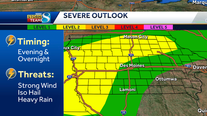
The initial focus zone for storms this evening is from northern Iowa back into western Iowa.
A boundary currently stretches from near Sioux City over into southeast Minnesota. Storms look to form along this boundary between 5-7 p.m., then drift southeast into this evening. Some of these cells could produce some hail early on. If these northern storms haven’t congealed into a line by 8-9 p.m., they’ll likely weaken before making it down to I-80. If they get organized faster, there’s a better chance of some stronger wind gusts after dark.
Farther west, another cluster of storms looks to fire up around Omaha & Council Bluffs after dark. These will drift into western Iowa with an isolated hail and wind threat the first half of tonight.
The leftovers of these two clusters of storms will move into central Iowa overnight, likely weakening as they arrive. Heavy rain will be the main concern during the overnight hours.
Tuesday Onward
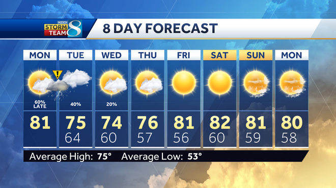
Tomorrow, clouds will linger across most of Iowa — thinnest to the north, thickest to the south. Scattered showers and some non-severe storms will be around much of the day along/south of I-80 due to low pressure spinning by through Missouri.
The cloud cover will keep daytime temperatures down in the mid-70s.
Wednesday, just an isolated shower remains possible, and clouds should be on the decrease.
Sunshine is back full force Thursday into the weekend, and temperatures will rise into the low 80s. A cold front will come through Iowa early Saturday, but this will mainly just drop our humidity and shift winds around to the north.
8:00 PM: Severe Thunderstorm Warnings in northern Iowa
<
p class=”body-text”>A line of storms continues to slowly sink southward through north-central Iowa this evening.
Two severe thunderstorm warnings are in effect for parts of Humboldt, Webster, and Wright counties until 8:45 p.m.
Storms in these areas could produce hail up to 1″ in diameter and wind gusts up to 60 mph.
This line of storms along Hwy. 3 is moving south at about 20 mph. So far, hail the size of peas to marbles has been reported.
Interactive Radar | Weather Alerts | Skycams
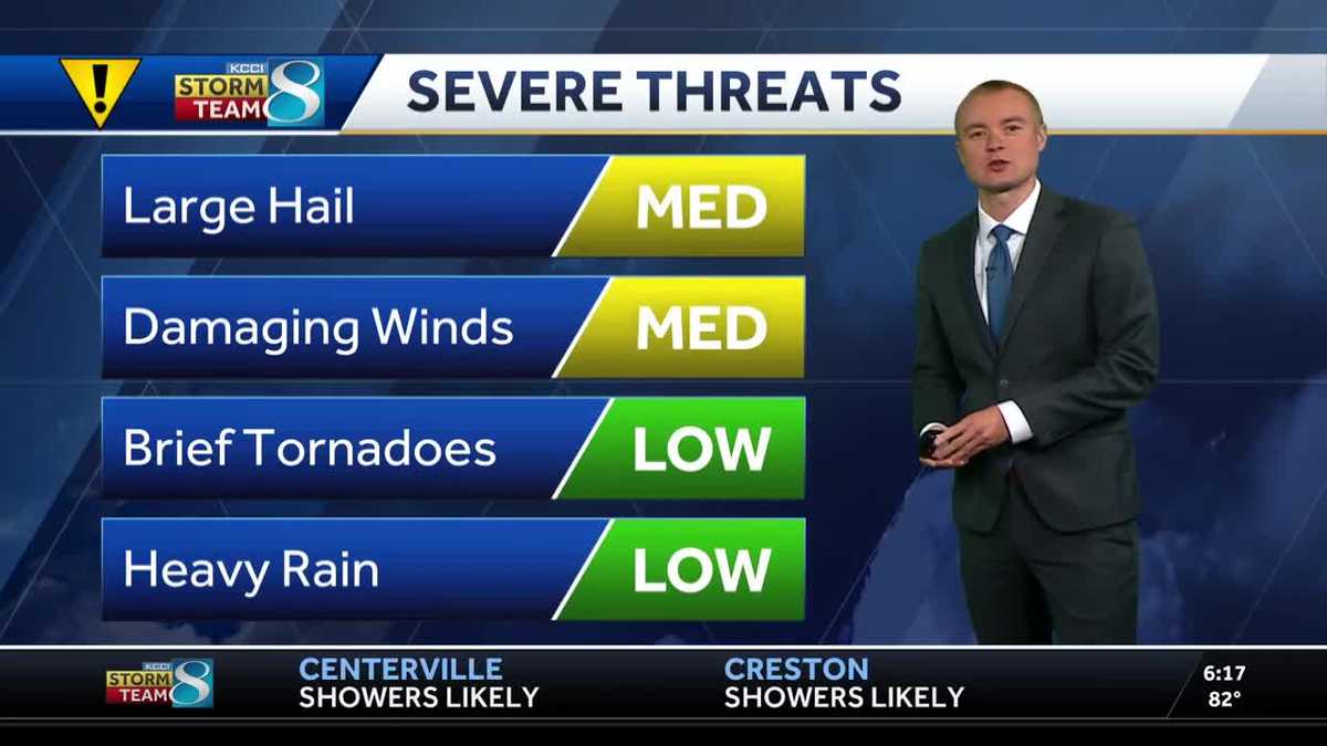
Large hail, damaging winds possible
The initial focus zone for storms this evening is northern Iowa.
A boundary currently stretches from near Sioux City over into southeast Minnesota. Storms look to form along this boundary between 5-7 p.m., then drift southeast into this evening. Some of these cells could produce some hail early on. If these northern storms haven’t congealed into a line by 8-9 p.m., they’ll likely weaken before making it down to I-80. If they get organized faster, there’s a better chance of some stronger wind gusts after dark.
Farther west, another cluster of storms looks to fire up around Omaha & Council Bluffs after dark. These will drift into western Iowa with an isolated hail and wind threat the first half of tonight.
The leftovers of these two clusters of storms will move into central Iowa overnight, likely weakening as they arrive. Heavy rain will be the main concern during the overnight hours.
Temps dip into 70s before slight weekend warm-up
Tomorrow, clouds will linger across most of Iowa — thinnest to the north, thickest to the south. Scattered showers and some non-severe storms will be around much of the day along/south of I-80 due to low pressure spinning by through Missouri.
The cloud cover will keep daytime temperatures down in the mid-70s.
Wednesday, just an isolated shower remains possible, and clouds should be on the decrease.
Sunshine is back full force Thursday into the weekend, and temperatures will rise into the low 80s. A cold front will come through Iowa early Saturday, but this will mainly just drop our humidity and shift winds around to the north.
Timelapse: Morning fog moves through downtown Des Moines
Keep an eye on weather across Iowa with KCCI’s skycams
Weather watchers can keep an eye on conditions by checking our skycam page, which shows aerial views from 20 sites across the state.
Iowa weather forecast
Today: Partly to mostly sunny. Storms possible later in the evening, first to the northwest. High 81F. Winds S at 5 to 10 mph.
Tonight: Scattered storms possible. A chance for some severe thunderstorms this evening and overnight. Highest chance north and west. Low 64F. Winds ESE at 5 to 10 mph.
Tomorrow: Mostly cloudy. Scattered showers, especially in southern Iowa. High 75F. Winds NE at 5 to 10 mph
Tomorrow night: Cloudy with occasional showers. Low 60F. Winds NE at 5 to 10 mph.
</div>


