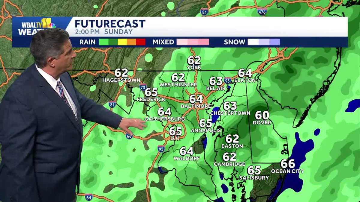
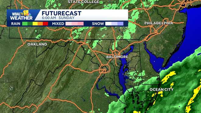
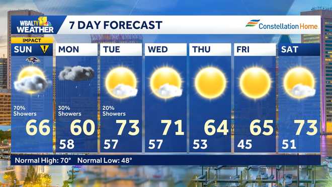
NORMAL. HIGH TEMPERATURE. THIS TIME OF YEAR IS 70 DEGREES TODAY. WE WERE STUCK IN THE 60S FOR MOST OF THE DAY AND THAT’S WHERE IT IS RIGHT NOW. 64 AT BWI MARSHALL. THE WINDS JUST STARTING TO PICK UP NOW OUT OF THE NORTHEAST. AT 12. IT WILL GET STRONGER AS WE GO THROUGH THE NIGHT AND INTO TOMORROW AS THIS BIG STORM GETS ORGANIZED THAT WE WERE TALKING ABOUT, BUT NOT TOO WINDY RIGHT NOW. TEMPERATURES IN THE 60S ELSEWHERE EVENTUALLY DROP INTO THE UPPER 50S AND LOW 60S. BY TOMORROW MORNING, IT’S ALREADY DOWN TO 59 IN FREDERICK, BUT IT’S STILL 67 DEGREES. TOP OF THE HOUR IN ANNAPOLIS. AND IF YOU’VE BEEN OUT THIS EVENING, YOU KNOW WE’VE SEEN A FEW PASSING RAIN SHOWERS. THOSE WILL CONTINUE OVERNIGHT TONIGHT. YOU CAN SEE THEM COMING IN FROM THE EAST TO THE WEST. THE BIG STORM IS STILL OFF TO OUR SOUTH. IT’S JUST GETTING ORGANIZED OFF THE SOUTHEAST COAST. AS WE MENTIONED, I THINK BALTIMORE IS GOING TO MISS THE WORST OF IT. IT’S NOT GOING TO BE A NICE DAY TOMORROW, BUT WE SHOULD MISS THE WORST OF IT. BUT AT THE BEACH IT WILL BE A DIFFERENT STORY. IT COULD BE KIND OF BUMPY AT OCEAN CITY AND ALL THE DELMARVA BEACHES. SO LET’S TAKE A LOOK AT OUR FUTURE CAST. I’LL LET YOU KNOW WHAT YOU CAN EXPECT RAIN WISE AS WE HEAD INTO TOMORROW. THIS IS 6:00 IN THE MORNING. SOME SCATTERED SHOWERS AROUND IN THE MORNING, BUT THE FURTHER WE GO INTO THE AFTERNOON, THE BETTER. THE CHANCE THAT SOME RAIN WILL CATCH UP TO US. I DON’T EXPECT ANY HEAVY RAIN AROUND. THIS IS 6:00 TOMORROW EVENING, BUT WE COULD SEE SOME POCKETS OF MODERATE RAIN COME THROUGH FROM TIME TO TIME. THE WIND MIGHT BE A BIGGER STORY THAN THE RAIN. WE COULD USE A LOT OF RAIN, BUT WE’RE NOT GOING TO GET A LOT. I DON’T THINK ON SUNDAY, GENERALLY UNDER A HALF INCH OF RAIN IN MOST PLACES, WITH THE HEAVIER AMOUNTS ON THE EASTERN SHORE AND DOWN TOWARDS THE BEACHES, BUT THE WINDS WILL GUST UP CLOSE TO 30MPH. AROUND BALTIMORE. IT WILL BE WORSE AT THE BEACH THOUGH. THIS IS OUR FORECAST FOR 5 P.M. ON SUNDAY. THE EUROPEAN MODEL FORECASTING WIND GUSTS 54 55MPH AT OCEAN CITY. THAT’S ALMOST LIKE TROPICAL STORM CONDITIONS. THERE’LL BE A LOT OF BEACH EROSION AND SOME COASTAL FLOODING ALONG THE DELMARVA BEACHES AS WELL. THE FORECAST HERE AT HOME MOSTLY CLOUDY TONIGHT. CHANCE FOR SHOWERS. BREEZY. TEMPERATURES DROP BACK INTO THE UPPER 50S AND LOW 60S DURING THE DAY TOMORROW. IT’S GOING TO BE WINDY. GUSTS UP TO 30MPH POSSIBLE OFF AND ON. RAIN SHOWERS ARE LIKELY. THE HIGH TEMPERATURES IN THE MID 60S ON MONDAY, SOME RAIN IS GOING TO STICK AROUND AND IT’S STILL GOING TO BE WINDY ON MONDAY AS WELL. THE HIGH NEAR 64 DEGREES AND THEN THE STORM WILL START TO PULL AWAY THE REST OF THE WEEK. THE WEATHER LOOKS PRETTY QUIET. NICE ACTUALLY. THE HIGH TEMPERATURES A LITTLE BELOW NORMAL, BUT SUNSHINE. WEDNESDAY, THURSDAY AND FRIDAY PROBABLY SATURDAY AS WELL WITH HIGHS IN TH
<div class="mobile">
Impact Weather on Sunday with strong wind gusts, rain expected across Baltimore region
                        <div class="article-branding">
                    <img src="https://www.jubi24.com/wp-content/uploads/2025/10/wbal.png" class="lazyload lazyload-in-view branding" alt="WBAL logo"/>

        Updated: 12:16 AM EDT Oct 12, 2025

    <a href="https://www.wbaltv.com/article/hearst-television-news-policy-statements/14471973" class="editorial-standards border-left">Editorial Standards <span class="info-icon">ⓘ</span></a>
</div>

                        <!-- article/blocks/byline -->
                    </div>
                </div>


                    The Baltimore region will see some strong wind gusts and rain at times throughout the day on Sunday. || Closings/Delays | Weather Advisories | Radar | Forecast | Email Alerts | Send us your pics ||It'll be a Weather Impact Day on Sunday as widespread showers will arrive by the afternoon. Some of the rain could be heavy at times off-and-on Sunday night into Monday.The Maryland State Highway Administration released a statement Friday, saying it's monitoring the storm and is preparing by clearing storm drains, organizing tree contractors and preparing equipment used in emergency responses.The SHA reminds everyone to stay off the roads as much as possible and to avoid driving through standing water. Additionally, the SHA said to avoid downed or damaged power and transmission lines that could still be live; remain cognizant of fallen trees or tree limbs in or near roads; and treat intersections where traffic signals are out or on flash as a all-way stop.Drivers who become disabled or are involved in a crash are advised to move as far off the road as possible, use hazard lights and dial #77.While Sunday's rain is not related to Tropical Storm Jerry, which was moving through the eastern part of the Caribbean, it could impact rip currents in Maryland (see map below). It will pose no threat to the U.S., according to the National Hurricane Center.Download the WBAL-TV app NOW and turn on push alerts to be aware of severe weather warnings, listen to NOAA Weather radio, and watch WBAL-TV 11 when impending severe weather develops.@wbaltv11 | @TTasselWBAL | @AvaWBAL | @TonyPannWBAL | @DalenciaWBAL | @AlenaLeeWXWBAL-TV 11 Maryland Weather RadarApp users tap here for interactive radar.Maryland's 7-Day Weather ForecastAlert Days vs. Impact DaysYou may see the WBAL-TV 11 Weather Team highlight Alert Days or Impact Days in the forecasts. Here's what that means:An Impact Day is when weather will likely disrupt your normal daily schedule or routine.An Alert Day is when there's a threat of extreme, severe and possibly life-threatening weather.Potential power outagesStorm conditions could cause outages by knocking down tree limbs onto power lines and other electric delivery equipment. Baltimore Gas and Electric asks all customers to report their outage in any of the following ways: Online, at BGE.comBGE's free mobile app, available at the Apple Store or Google Play  Text message, to 69243 Phone, by calling 877-778-2222The latest outage information, including total number and general locations, is available on the BGE.com outage map.As a reminder, fallen overhead power lines should never be approached or touched even if the lines do not appear to be live or sparking. Call BGE at 877-778-2222 to report fallen electrical lines, power outages and gas odors.Share your weather photos and videosWhen and where safe, show us your weather photos and videos, we may show them on 11 News or online!DIRECT UPLOAD: Use this form to upload photos or video.EMAIL: Just email your photos and video to news@wbaltv.com.ALERTS: Severe weather alerts from the WBAL-TV app: step-by-step guideCLOSINGS: See if schools, businesses or organizations have closed or delayedRADAR: Track snow, sleet or freezing rain with WBAL-TV's interactive radarROADS: Check for crashes and backups with our interactive traffic mapWINTER: Guide: Snow safety, driving hazards, power outagesTORNADO SURVIVAL: 5 things you need to do nowHURRICANE PREPARATION: How to prepare for hurricane season


                <div class="article-content--body-text">
                    <strong class="dateline">BALTIMORE —</strong>                                                   The Baltimore region will see some strong wind gusts and rain at times throughout the day on Sunday.
|| Closings/Delays | Weather Advisories | Radar | Forecast | Email Alerts | Send us your pics ||
It’ll be a Weather Impact Day on Sunday as widespread showers will arrive by the afternoon. Some of the rain could be heavy at times off-and-on Sunday night into Monday.
The Maryland State Highway Administration released a statement Friday, saying it’s monitoring the storm and is preparing by clearing storm drains, organizing tree contractors and preparing equipment used in emergency responses.
The SHA reminds everyone to stay off the roads as much as possible and to avoid driving through standing water. Additionally, the SHA said to avoid downed or damaged power and transmission lines that could still be live; remain cognizant of fallen trees or tree limbs in or near roads; and treat intersections where traffic signals are out or on flash as a all-way stop.
Drivers who become disabled or are involved in a crash are advised to move as far off the road as possible, use hazard lights and dial #77.
While Sunday’s rain is not related to Tropical Storm Jerry, which was moving through the eastern part of the Caribbean, it could impact rip currents in Maryland (see map below). It will pose no threat to the U.S., according to the National Hurricane Center.
Download the WBAL-TV app NOW and turn on push alerts to be aware of severe weather warnings, listen to NOAA Weather radio, and watch WBAL-TV 11 when impending severe weather develops.
@wbaltv11 | @TTasselWBAL | @AvaWBAL | @TonyPannWBAL | @DalenciaWBAL | @AlenaLeeWX
WBAL-TV 11 Maryland Weather Radar
App users tap here for interactive radar.
Maryland’s 7-Day Weather Forecast
Alert Days vs. Impact Days
You may see the WBAL-TV 11 Weather Team highlight Alert Days or Impact Days in the forecasts. Here’s what that means:
- An Impact Day is when weather will likely disrupt your normal daily schedule or routine.
- An Alert Day is when there’s a threat of extreme, severe and possibly life-threatening weather.
Potential power outages
Storm conditions could cause outages by knocking down tree limbs onto power lines and other electric delivery equipment. Baltimore Gas and Electric asks all customers to report their outage in any of the following ways:
The latest outage information, including total number and general locations, is available on the BGE.com outage map.
As a reminder, fallen overhead power lines should never be approached or touched even if the lines do not appear to be live or sparking. Call BGE at 877-778-2222 to report fallen electrical lines, power outages and gas odors.
Share your weather photos and videos
When and where safe, show us your weather photos and videos, we may show them on 11 News or online!
                                        </div>


                                                    </div>//platform.twitter.com/widgets.js


